Run ReWaterGAP with Karst (Under Construction)#
This tutorial introduces the modifications in ReWaterGAP for handling karst regions and explains the required input files, as well as the assessment methods.
Introduction#
[Insert Introduction here]
Implemented Modifications#
The following extensions and changes need to be made to the code:
Fraction of karstification#
A fraction of the continental area is defined as karst. For this fraction, the runoff component (R3) is treated as groundwater recharge.
Groundwater recharge factor (fg)#
The original calculation of fg has to be replaced by an externally provided input factor.
Semi-arid coarse-texture adjustment#
A grid-cell-specific indicator allows special handling of (semi-)arid regions. If a semi-arid grid cell has R<sub>gmax</sub> > 5 mm/d (indicating coarse texture), groundwater recharge occurs only when precipitation exceeds 12.5 mm/d (instead of being triggered solely by coarse texture).
Maximum groundwater recharge dataset#
A dataset specifying the maximum possible groundwater recharge rate (mm/d) needs to be implemented
Input Files#
ReWaterGAP requires additional input files for the karst extensions:
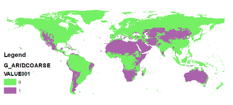
G_ARIDCOARSE.UNF2#
The input file for indicating coarse arid gird cells
Value: 1
Unit: [-]
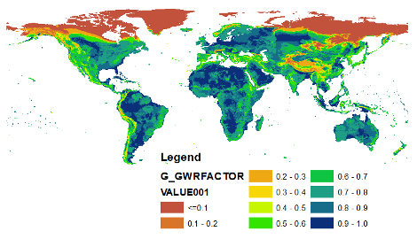
G_GWRFACTOR.UNF0#
The input file for groundwater recharge factor
Range: 0 – 1
Unit: [-]
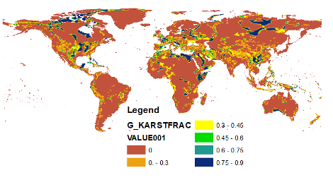
G_KARSTFRAC.UNF0#
The input file for karst fraction
Range: 0 – 0.9
Unit: [-]
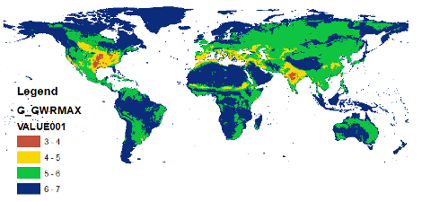
G_GWRMAX.UNF2#
Specifies the maximum groundwater recharge rate.
The input file for gwr max
Range: 3 – 7
Unit: [mm/d]
Assessments#
To evaluate the impact of the modifications, the following assessments are recommended:
Water balance#
Streamflow evaluation#
Validate model outputs against observed streamflow